Hurricanes in Mississippi
When is Hurricane Season in Mississippi?
The official hurricane season in Mississippi is in fact the Atlantic hurricane season, beginning on June 1 and ending on November 30. This is the period each year when most tropical cyclones form in the Atlantic basin.
Historically, the state has witnessed the landfall of 19 major hurricanes, ranking it seventh among U.S. states for major hurricane strikes. Additionally, it has seen the formation of 63 tropical storms and 35 tropical depressions, indicating that it's a significant region for storm activity. This data comes from the archives of the National Hurricane Center.

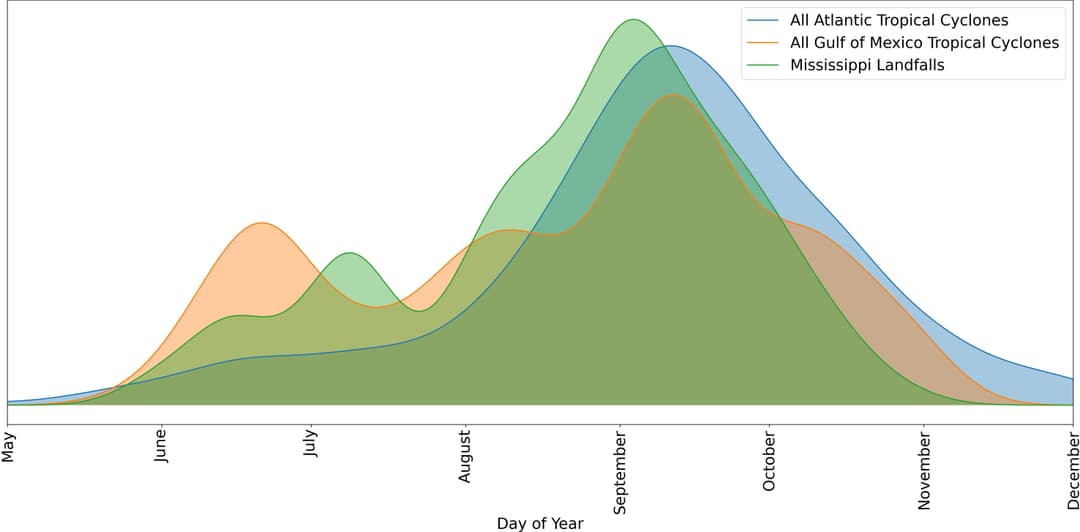
Using raw data from the NOAA Hurricane Research Division, we have generated a graph that illustrates the probability of hurricane occurrence in Mississippi based on historical storm data dating back to 1851. This graph compares the daily probabilities of Atlantic basin, Gulf-originated storms, and actual tropical storm landfalls in Mississippi.
The graph shows a clear spike in tropical storm activity in June, characteristic of storms originating in the Gulf of Mexico. However, the highest likelihood of a hurricane is still in September. The Gulf of Mexico sometimes produces early storms due to the warm waters that fuel storm development. An example of a serious Gulf-originated storm is Hurricane Camille in 1969, which resulted in significant devastation in Mississippi.
According to Texas A&M University, these early-formed Gulf hurricanes can be devastating due to the proximity of land, which limits the time for preparation and evacuation.
Where do Hurricanes Hit the Most in Mississippi?
In Mississippi, the coastal counties of Harrison, Hancock, and Jackson bear the brunt of the hurricanes. These counties are frequently exposed to hurricane-force winds, storm surge, and flood conditions resulting from the hurricane's landfall.
Hurricanes Katrina (2005), Gustav (2008), and Isaac (2012) caused significant flooding to all three coastal counties in Mississippi.

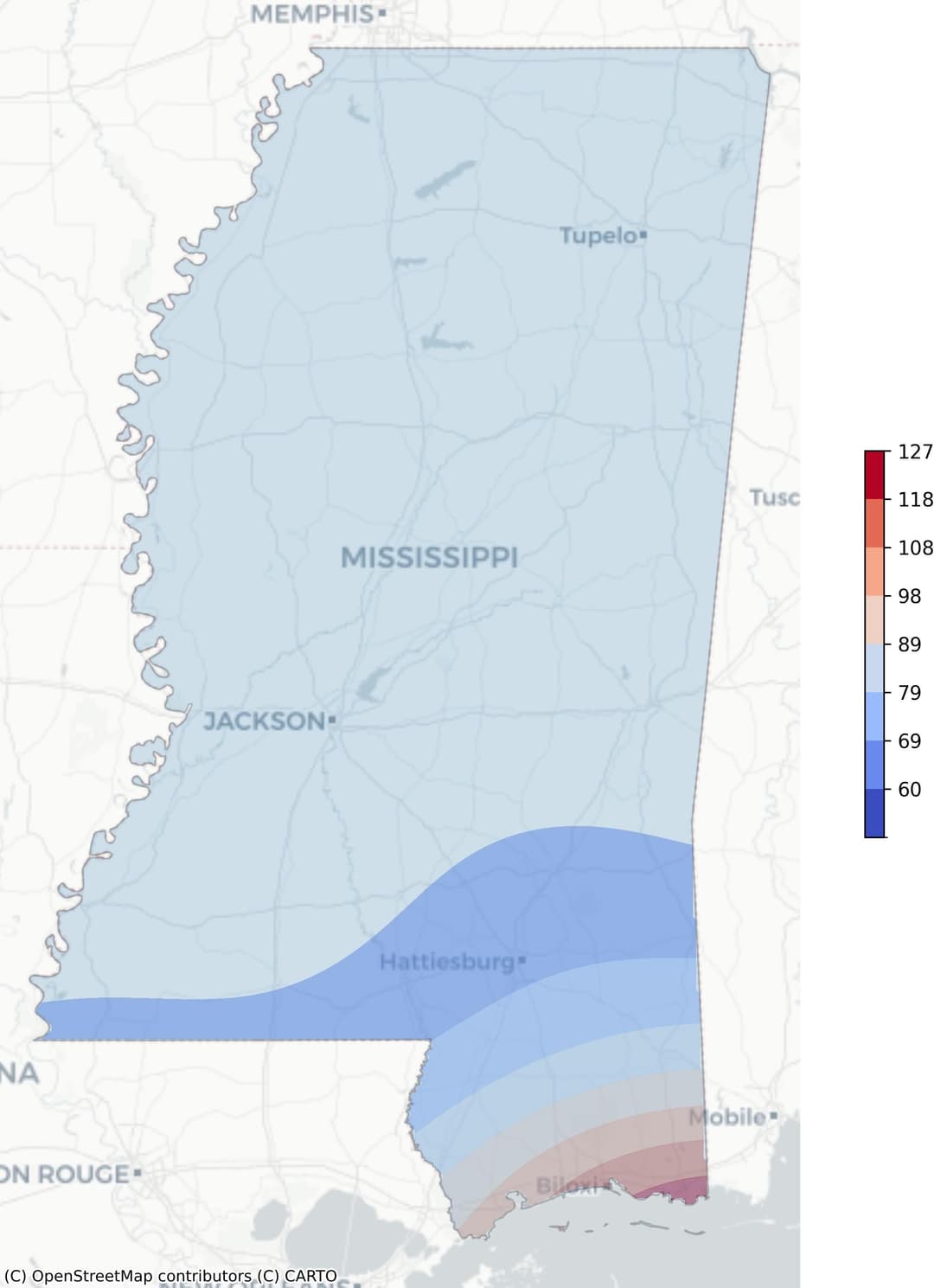
The provided image depicts a hurricane risk heatmap for Mississippi. The colors on the map range from blue to red, representing the frequency of hurricane occurrences weighted by wind speed. Blue areas indicate regions with fewer hurricane hits or lower wind speeds, while red zones frequently experience hurricanes with high wind speeds.
As per the graph, the coastal counties mentioned above are the most susceptible to hurricanes, depicted by the intense red color. This suggests a high frequency of hurricanes with strong wind speeds in these areas.
What Are The Recent Hurricanes in Mississippi?
Hurricane Zeta, 2020 - This hurricane caused severe damage, particularly in the coastal counties of Hancock, Harrison, and Jackson. Sustained hurricane-force winds led to numerous downed power lines and poles and damage to up to 10,000 homes. The most extreme damage was in Harrison County, where one person died from the storm surge. The overall estimated damage was about $1.25 billion, with more than 3,000 people housed in shelters and about half a million customers losing power at some point during the hurricane.
Hurricane Nate, 2017 - Though no direct deaths were reported in the United States, Hurricane Nate was indirectly responsible for two fatalities due to traffic accidents. The hurricane caused significant damage to the infrastructure and agriculture, particularly in Central America.
Hurricane Katrina, 2005 - One of the deadliest and costliest hurricanes to strike the United States, Katrina resulted in immense loss of life and property damage. In Mississippi, the storm surge struck the coastline, obliterating entire coastal communities. The majority of fatalities in Mississippi were likely directly caused by the storm surge in the three coastal counties. The total number of fatalities was 1,392, with 520 direct deaths and 565 indirect deaths. The estimated damage from Katrina was staggering, with thousands of homes and businesses destroyed, large loss of jobs, and millions of dollars in lost tax revenues.
How to Prepare for A Hurricane Season in Mississippi
Preparing for a hurricane season is crucial, particularly for residents of states like Mississippi, where such weather events are not uncommon. Proper preparation empowers individuals and communities to respond effectively when a hurricane strikes, reducing the risk of adverse outcomes.
Before a Hurricane
When it comes to hurricane safety, preparation is key. Here is a short hurricane preparation checklist that could be instrumental in ensuring hurricane preparedness:
Stay Informed: Keep up-to-date with the latest weather forecasts and official information about the potential hurricane.
Create an Emergency Plan: Discuss and establish an evacuation plan with your family. Make sure everyone understands where to go and what to do in case of a hurricane.
Prepare Your Home: Secure your property. Reinforce windows and doors, clear rain gutters, and trim trees near your house.
Assemble a Disaster Supply Kit: Stock up on necessary supplies such as non-perishable food, water, medications, and important documents. Remember to include supplies for your pets.
Check Insurance Coverage: Ensure that your insurance policies cover the hazards associated with hurricanes and floods.
Know Your Evacuation Zone: Familiarize yourself with the local evacuation zone and the route to the nearest shelter.
During a Hurricane
When a hurricane hits, ensuring safety is paramount. Here are some key actions for staying safe during a hurricane in Mississippi:
- Stay informed: Keep track of the storm's progress through trusted sources such as the National Weather Service.
- Evacuate if instructed: Follow the directions of local authorities if an evacuation order is given.
- Prepare your home: Secure loose items outside your home, board up windows, and ensure that your home is as stormproof as possible.
- Stock up on essentials: Have a disaster supply kit ready with items such as bottled water, non-perishable food, medication, and essential documents.
- Stay indoors: During the hurricane, stay away from windows and doors. It's safest to be in a small, windowless, ground-floor interior room.
- Be cautious after the hurricane: Avoid flooded areas and downed power lines, and don't drink tap water until local officials say it's safe.
After a Hurricane
The aftermath of a hurricane can be devastating and overwhelming. Here is a short list of steps to help manage the situation more effectively.
- Step 1: Ensure Safety: The first and foremost priority is to ensure your safety and that of others. Stay indoors until local authorities confirm it's safe to go outside.
- Step 2: Assess Damage: Once it's safe, assess the damage to your property. Document all damages for insurance claims. Remember to take photographs for evidence.
- Step 3: Communicate: Reach out to family and friends to let them know you're safe. If you're unable to communicate, you can register with the Red Cross Safe and Well website.
- Step 4: Seek Help: Contact FEMA (Federal Emergency Management Agency) for disaster assistance. You can apply online, via mobile app or by calling the FEMA Helpline.
- Step 5: Clean Up: Begin the clean-up process once you've ensured your safety and communicated with the necessary parties. Be mindful of potential hazards such as downed power lines or contaminated water.
- Step 6: Plan Ahead: After immediate needs are addressed, start planning for the long-term recovery. This includes repairing or rebuilding your home, returning to work, and restoring daily routines.
Knowing what to do after a hurricane is essential. Stay informed, stay safe, and seek help from professional organizations like FEMA.